


Compass Pro (Altitude, Speed Location, Weather)

Compass Pro (Altitude, Speed Location, Weather)介绍
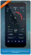
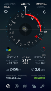
Compass Pro is the app for professionals as well as amateurs! Compass Pro is a real compass! It shows device real-time orientation to magnetic fields. It's displays lot of useful information like location, altitude, speed, magnetic field, barometric pressure, etc.
Compass Pro is easy to use. Following a particular bearing is easier too. Just tap on button to set a particular bearing and the app will then draw a red arc around the inside of the compass circle to indicate how far you’re deviating from your set course.
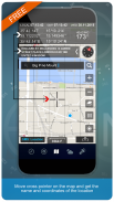
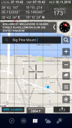
Compass pro has a map with lot of functionalities. Different map types, SMS your location, search any place, move cross pointer on the map and get the name and coordinates of the location.
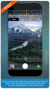
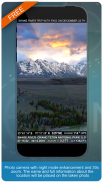
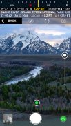
Photo camera with night mode enhancement and zoom. The name and full information about the location will be placed on the taken photo.
Coordinates are shown in next formats:
- Dec Degs (DD.dddddd˚)
- Dec Degs Micro (DD.dddddd "N, S, E, W")
- Dec Mins (DDMM.mmmm)
- Deg Min Secs (DD°MM'SS.sss")
- Dec Mins Secs (DDMMSS.sss")
- UTM (Universal Transverse Mercator)
- MGRS (Military Grid Reference System)
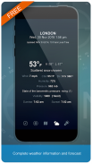
Complete weather information and forecast.
1. Compass
--- Shows device real-time orientation to magnetic fields.
--- Ability to switch between true and magnetic North.
--- Particular bearing
--- Location coordinates (longitude, latitude).
--- Course
--- Speed
--- Altitude
--- Ability to switch between mph, feet units and kmh, meter units.
2. Camera
--- Location Stamp photos
--- Zoom
--- Light Amplifier
--- Flashlight
3. Map
--- Current date and time.
--- Current GMT time.
--- Standard, satellite, hybrid, terrain maps.
--- Current location.
--- Location search.
--- Location name.
--- SMS location
4. Weather
--- Temperature information.
--- Humidity
--- Pressure
--- Ability to switch between Celsius and Fahrenheit.
Compass Pro是专业人士和业余爱好者的应用程序!指南针Pro是一个真正的指南针!它显示设备对磁场的实时定向。它显示许多有用的信息,例如位置,高度,速度,磁场,大气压等。
Compass Pro易于使用。遵循特定的轴承也更容易。只需点击按钮即可设置特定的方位,然后该应用将在罗盘圆的内部绘制一个红色弧线,以指示您偏离设定路线的距离。
指南针专业版具有很多功能的地图。不同的地图类型,通过短信发送您的位置信息,搜索任何地方,在地图上移动十字指针,并获取位置的名称和坐标。
具有夜间模式增强和变焦功能的相机。名称和有关位置的完整信息将被放置在所拍摄的照片上。
坐标以以下格式显示:
-Dec Degs(DD.dddddd˚)
-Dec Degs Micro(DD.dddddd“ N,S,E,W”)
-12月分钟(DDMM.mmmm)
-Deg Min Secs(DD°MM'SS.sss“)
-Dec Mins Secs(DDMMSS.sss“)
-UTM(通用横轴墨卡托)
-MGRS(军事网格参考系统)
完整的天气信息和预报。
1.指南针
---显示设备对磁场的实时定向。
---能够在真北之间切换。
---特殊轴承
---位置坐标(经度,纬度)。
---课程
-速度
-海拔
---可以在mph,英尺单位和kmh,米单位之间切换。
2.相机
---位置邮票照片
-缩放
---光放大器
---手电筒
3.地图
---当前日期和时间。
---当前GMT时间。
---标准,卫星,混合,地形图。
- - 当前位置。
---位置搜索。
- - 地点名称。
-短信位置
4.天气
---温度信息。
-湿度
---压力
---可以在摄氏和华氏之间切换。
Compass Pro (Altitude, Speed Location, Weather) - 版本2.3
(28-02-2020)
Compass Pro (Altitude, Speed Location, Weather) - APK信息
APK版本: 2.3程序包: com.dragon.compassproCompass Pro (Altitude, Speed Location, Weather)的最新版本
其他版本


同类应用

您可能还会喜欢……


